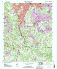
1993 Map of Gastonia South
USGS Topo · Published 1996About this map
Gastonia expansion and rural South Carolina borderlands meet in this mid-1990s record of development. The map documents the southern fringes of the city, where established neighborhoods near Sherwood Park and Huss High Sch transition into the rolling terrain of the Gaston and York County line. A notable piece of industrial transit history is visible in the Dismantled Railroad corridor that snakes southward toward the state line.
Find a feature on this map
54 named features on this map. Tap any name to fly to it.
Don’t see what you’re looking for? This feature index may not catch every label — zoom into the map to look around manually.
Map Details
Editions of this 1993 Gastonia South Map
This is the sole edition of this map. No revisions or reprints were ever made.
Other maps of this area

1906 · Kings Mountain
USGS Topo · 1:62,500

1908 · Kings Mountain
USGS Topo · 1:62,500

1909 · Lincolnton
USGS Topo · 1:62,500

1911 · Lincolnton
USGS Topo · 1:62,500

1914 · Gastonia
USGS Topo · 1:48,000

1916 · Gastonia
USGS Topo · 1:62,500

1947 · Clover
USGS Topo · 1:62,500

1949 · Clover
USGS Topo · 1:62,500

1953 · Charlotte
USGS Topo · 1:250,000

1954 · Charlotte
USGS Topo · 1:250,000