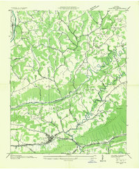
1935 Map of Gate City
USGS Topo · Published 1935About this map
The Clinch River and its accompanying ridges dominate this 1935 survey of Scott County, Virginia. The landscape is defined by the tight corridors of Moccasin Valley and Poor Valley, where small-scale agriculture and industry took hold during the mid-Depression era. Significant local landmarks include a series of water-powered operations such as Jayne Mill and Williams Mill, alongside a dense network of community centers like Starnes Bluff Ch, Farleys Chapel, and the Red Hill Sch. The town of Gate City serves as the focal point for transportation, situated where the Southern RR meets U S Highway No 58 at the strategic Moccasin Gap. This topographic study by the Tennessee Valley Authority reveals a rural economy still reliant on its natural watercourses and the proximity of the Southern RR for connectivity beyond the ridges.
Find a feature on this map
67 named features on this map. Tap any name to fly to it.
Don’t see what you’re looking for? This feature index may not catch every label — zoom into the map to look around manually.
Map Details
Editions of this 1935 Gate City Map
This is the sole edition of this map. No revisions or reprints were ever made.
Other maps of this area

1894 · Estillville
USGS Topo · 1:125,000

1897 · Bristol
USGS Topo · 1:125,000

1902 · Bristol
USGS Topo · 1:125,000

1920 · Wise
USGS Topo · 1:48,000

1920 · Coeburn
USGS Topo · 1:48,000

1921 · Wise
USGS Topo · 1:62,500

1935 · Hilton
USGS Topo · 1:24,000

1935 · Moggasin
USGS Topo · 1:48,000

1935 · East Stone Gap
USGS Topo · 1:24,000

1935 · Kingsport
USGS Topo · 1:24,000