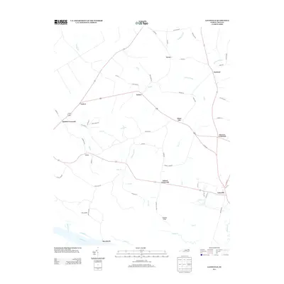
2013 Map of Gatesville
USGS Topo · Published 2013About this map
Gatesville and the surrounding coastal plain of Gates County are defined by a complex network of blackwater streams and wetlands. The landscape is characterized by prominent hydrologic features such as Hackley Swamp and Cypress Swamp, which dominate the low-lying areas between small agrarian communities. Local travel in the early 21st century remains anchored to historic junctions like Riddick Crossroads and Eleanors Crossroads, showing how original settlement patterns persisted even as modern roads replaced early trails. Along the southern edge, the Chowan River and Rays Beach mark the transition to the riverine environment, with Fort Island standing as a distinct landmark in the wetlands. Numerous family-named branches, including Buckland Mill Br and Jady Br, suggest a long history of local land ownership and small-scale water-powered industry that once supported the rural economy of settlements like Roduco and Sarem.
Find a feature on this map
64 named features on this map. Tap any name to fly to it.
Don’t see what you’re looking for? This feature index may not catch every label — zoom into the map to look around manually.
Map Details
Editions of this 2013 Gatesville Map
This is the sole edition of this map. No revisions or reprints were ever made.
Other maps of this area

1906 · Beckford
USGS Topo · 1:48,000

1907 · Beckford
USGS Topo · 1:62,500

1908 · Winton
USGS Topo · 1:62,500

1919 · Suffolk
USGS Topo · 1:62,500

1920 · Holland
USGS Topo · 1:62,500

1940 · Beckford
USGS Topo · 1:62,500

1943 · Holland
USGS Topo · 1:62,500

1953 · Norfolk
USGS Topo · 1:250,000
1954 · Suffolk
USGS Topo · 1:62,500

1957 · Holland
USGS Topo · 1:62,500