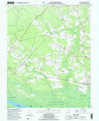
2000 Map of Gatesville
USGS Topo · Published 2002About this map
Chowan Swamp State Game Land dominates the southern reaches of this North Carolina landscape, where the Chowan River forms the border between Gates and Hertford counties. The town of Gatesville serves as a focal point near the eastern edge, while the surrounding countryside is defined by a network of crossroads settlements and small country churches. Places such as Riddick Crossroads and Ballard Crossroads highlight the historic importance of overland travel routes through the swampy lowlands. Numerous family and community landmarks are visible, including Ballards Grove Ch and New Hope Ch, alongside several cemeteries designated simply as Cem. The drainage patterns of the coastal plain are clearly illustrated by Cypress Swamp, Licking Branch, and Landing Creek, showing how water dictated the placement of farms and small hamlets like Roduco and Eure.
Find a feature on this map
41 named features on this map. Tap any name to fly to it.
Don’t see what you’re looking for? This feature index may not catch every label — zoom into the map to look around manually.
Map Details
Editions of this 2000 Gatesville Map
This is the sole edition of this map. No revisions or reprints were ever made.
Other maps of this area

1906 · Beckford
USGS Topo · 1:48,000

1907 · Beckford
USGS Topo · 1:62,500

1908 · Winton
USGS Topo · 1:62,500

1919 · Suffolk
USGS Topo · 1:62,500

1920 · Holland
USGS Topo · 1:62,500

1940 · Beckford
USGS Topo · 1:62,500

1943 · Holland
USGS Topo · 1:62,500

1953 · Norfolk
USGS Topo · 1:250,000
1954 · Suffolk
USGS Topo · 1:62,500

1957 · Holland
USGS Topo · 1:62,500