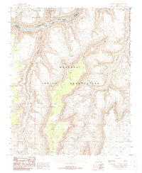
1988 Map of Gateway Rapids
USGS Topo · Published 1988About this map
The Colorado River carves a deep path through the northern reach of this 1988 landscape, where the turbulent white water of Gateway Rapids marks the descent through the canyon floor. This survey documents a critical intersection of western land management, showing the Park Boundary between Grand Canyon National Park and the extensive Hualapai Indian Reservation. The map captures the dramatic verticality of the terrain, defined by massive tributary systems like the winding Mohawk Canyon and the steep Stairway Canyon. The convergence of Mohave and Coconino counties occurs within this complex network of side canyons and high plateaus, illustrating the remote and inaccessible nature of the land before modern development touched these interior sections of the canyon system.
Find a feature on this map
13 named features on this map. Tap any name to fly to it.
Don’t see what you’re looking for? This feature index may not catch every label — zoom into the map to look around manually.
Map Details
Editions of this 1988 Gateway Rapids Map
This is the sole edition of this map. No revisions or reprints were ever made.
Other maps of this area

1886 · Mt. Trumbull
USGS Topo · 1:250,000

1886 · Kaibab
USGS Topo · 1:250,000

1892 · Mt. Trumbull
USGS Topo · 1:250,000

1953 · Grand Canyon
USGS Topo · 1:250,000

1957 · Grand Canyon
USGS Topo · 1:250,000

1958 · Grand Canyon
USGS Topo · 1:250,000

1960 · Grand Canyon
USGS Topo · 1:250,000

1962 · Tuckup Canyon
USGS Topo · 1:62,500

1962 · National Canyon
USGS Topo · 1:62,500
1967 · Vulcans Throne
USGS Topo · 1:24,000