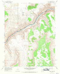
1967 Map of Vulcans Throne
USGS Topo · Published 1970About this map
Vulcans Throne stands as a prominent geological landmark overlooking the Colorado River in this detailed survey of the Arizona wilderness. The landscape is defined by the steep descent from the Toroweap Valley and the Toroweap Cliffs down to the riverbed, where the treacherous Lava Falls Rapids and the isolated Lava Pinnacle mark the canyon floor. To the south, the Hualapai Indian Reservation encompasses the Hualapai Valley and the sheer face of the Aubrey Cliffs.
Find a feature on this map
29 named features on this map. Tap any name to fly to it.
Don’t see what you’re looking for? This feature index may not catch every label — zoom into the map to look around manually.
Map Details
Editions of this 1967 Vulcans Throne Map
3 editions found
Other maps of this area

1886 · Mt. Trumbull
USGS Topo · 1:250,000

1886 · Kaibab
USGS Topo · 1:250,000

1892 · Mt. Trumbull
USGS Topo · 1:250,000

1953 · Grand Canyon
USGS Topo · 1:250,000

1957 · Grand Canyon
USGS Topo · 1:250,000

1958 · Grand Canyon
USGS Topo · 1:250,000

1960 · Grand Canyon
USGS Topo · 1:250,000

1962 · Tuckup Canyon
USGS Topo · 1:62,500

1962 · National Canyon
USGS Topo · 1:62,500
1967 · Whitmore Rapids
USGS Topo · 1:24,000