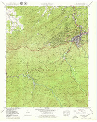
1979 Map of Gatlinburg
USGS Topo · Published 1979About this map
Gatlinburg is the central hub of this late-1970s survey, showing a landscape defined by the transition from a growing mountain town to the protected wilderness of the Great Smoky Mountains National Park. The map documents the expansion of tourism infrastructure, featuring a Ski Slope, the Sugarlands Visitor Information Center, and multiple housing developments like Chalet Village and Greystone Heights. To the west, the rugged terrain of Cove Mountain and the West Prong Little Pigeon River valley contain older traces of settlement, including Covemont Ch and several family burial sites such as Crowson Cem and Banner Cem.
Find a feature on this map
148 named features on this map. Tap any name to fly to it.
Don’t see what you’re looking for? This feature index may not catch every label — zoom into the map to look around manually.
Map Details
Editions of this 1979 Gatlinburg Map
3 editions found

Other maps of this area

1886 · Knoxville
USGS Topo · 1:125,000

1892 · Knoxville
USGS Topo · 1:125,000

1893 · Mt Guyot
USGS Topo · 1:125,000

1894 · Knoxville
USGS Topo · 1:125,000

1895 · Knoxville
USGS Topo · 1:125,000

1901 · Knoxville
USGS Topo · 1:125,000

1912 · Mt Guyot
USGS Topo · 1:125,000

1935 · English Mountain
USGS Topo · 1:48,000

1935 · Walden Creek
USGS Topo · 1:24,000

1935 · Richardson Cove
USGS Topo · 1:24,000