
1968 Map of Gavins Point Dam
USGS Topo · Published 1971About this map
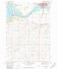
Yankton serves as a focal point on this late-1960s survey, situated along the northern bank of the Missouri River opposite the Nebraska state line. The map highlights the significant infrastructure associated with the Missouri River Basin development, including the Gavins Point National Fish Hatchery and the vast Lewis and Clark Lake formed behind the dam. Civic and religious life is well-documented with the inclusion of the Courthouse, City Hall, Sacred Heart Ch, and several cemeteries such as Aten Cem and Beaver Creek Cem. Across the water in Nebraska, small communities like South Yankton and Aten are connected by a landscape shaped by agricultural precincts like Frankfort Prec and Prec 2. The presence of the Fort Yankton Historic Site and the rural School No 87 provides a window into the regional heritage and the distribution of early education and historical landmarks in the mid-20th century.
Find a feature on this map
41 named features on this map. Tap any name to fly to it.
Don’t see what you’re looking for? This feature index may not catch every label — zoom into the map to look around manually.
Map Details
Editions of this 1968 Gavins Point Dam Map
2 editions found
Other maps of this area

1955 · Sioux City
USGS Topo · 1:250,000

1957 · Mission Hill
USGS Topo · 1:24,000

1958 · Sioux City
USGS Topo · 1:250,000

1959 · Sioux City
USGS Topo · 1:250,000

1968 · Tabor SE
USGS Topo · 1:24,000

1968 · Bloomfield NE
USGS Topo · 1:24,000

1968 · Crofton
USGS Topo · 1:24,000

1968 · Fordyce
USGS Topo · 1:24,000
1968 · Menominee
USGS Topo · 1:24,000
1978 · Tabor NE
USGS Topo · 1:24,000