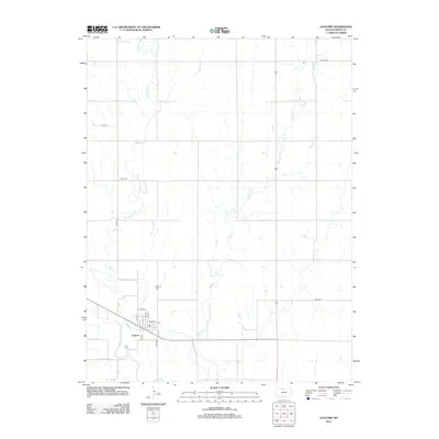
2012 Map of Gaylord
USGS Topo · Published 2012About this map
Gaylord anchors this Smith County landscape at the junction where Beaver Cr flows into the N Fork Solomon River. The town's grid is clearly defined, featuring a Po and primary thoroughfares like Main St and Elm St. The surrounding countryside is marked by a network of drainage systems, with Spring Cr meandering through the eastern portion of the quadrangle. For those researching local heritage, the map identifies two significant burial grounds: Gaylord Cem situated just north of the main settlement and Christ Cem located further northwest. The section lines and rural routes, such as Co RD-1553 and Cord-1060, reflect the enduring agricultural layout of the region, where watercourses and section roads dictate the movement across the Kansas plains.
Find a feature on this map
20 named features on this map. Tap any name to fly to it.
Don’t see what you’re looking for? This feature index may not catch every label — zoom into the map to look around manually.
Map Details
Editions of this 2012 Gaylord Map
This is the sole edition of this map. No revisions or reprints were ever made.
Other maps of this area

1893 · Smith Center
USGS Topo · 1:125,000

1955 · Beloit
USGS Topo · 1:250,000

1959 · Beloit
USGS Topo · 1:250,000

1961 · Portis
USGS Topo · 1:24,000

1961 · Harlan
USGS Topo · 1:24,000

1961 · Gaylord SW
USGS Topo · 1:24,000

1973 · Athol
USGS Topo · 1:24,000
1973 · Cedar
USGS Topo · 1:24,000
1973 · Smith Center
USGS Topo · 1:24,000
1973 · Portis NW
USGS Topo · 1:24,000