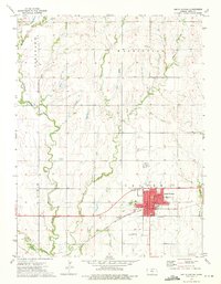
1973 Map of Smith Center
USGS Topo · Published 1975About this map
Smith Center serves as the focal point of this North Central Kansas survey, situated at the intersection of a established grid system and the Chicago Rock Island and Pacific railroad line. The town layout is clearly defined by named thoroughfares such as Main St, Kansas Ave, and New York Ave, surrounding civic landmarks including the Courthouse, Po, and City Hall. The surrounding agricultural landscape in Center, Pleasant, and Washington townships is dissected by several winding waterways, most notably Middle Beaver Creek and Troublesome Creek. Cultural and social life of the early 1970s is reflected in the presence of the Drive-in Theater on the eastern edge of town and Wagner Park near the center. To the south, the Smith Center Municipal Airport and a series of quarries indicate the local transportation and industrial activity of the era, while the Fairview Cemetery provides a significant touchstone for genealogical research.
Find a feature on this map
35 named features on this map. Tap any name to fly to it.
Don’t see what you’re looking for? This feature index may not catch every label — zoom into the map to look around manually.
Map Details
Editions of this 1973 Smith Center Map
This is the sole edition of this map. No revisions or reprints were ever made.
Other maps of this area

1893 · Smith Center
USGS Topo · 1:125,000

1955 · Beloit
USGS Topo · 1:250,000

1959 · Beloit
USGS Topo · 1:250,000

1973 · Athol
USGS Topo · 1:24,000
1973 · Cora
USGS Topo · 1:24,000
1973 · Reamsville
USGS Topo · 1:24,000
1973 · Cedar
USGS Topo · 1:24,000
1973 · Bachelors Run
USGS Topo · 1:24,000
1973 · Portis NW
USGS Topo · 1:24,000
1973 · Gaylord
USGS Topo · 1:24,000