1966 Map of Gays Mills
USGS Topo · Published 1968About this map
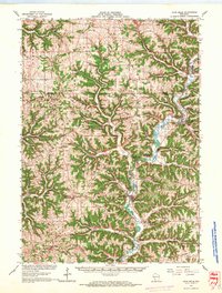
The Kickapoo River meanders through this deeply dissected landscape of the Driftless Area, connecting the river towns of Readstown, Soldiers Grove, and Gays Mills. In the mid-1960s, the region's agricultural character is defined by narrow ridges and steep-walled valleys, where numerous small settlements like Liberty Pole, Rising Sun, and Fargo occupy the higher ground. Local life is anchored by rural institutions such as the Southwest Prairie Ch, Utica Ch, and the Rising Sun Sch. The topography reveals a complex network of named ridges and hollows, including Mickelson Ridge, Boma Ridge, and Hornby Hollow. Near Gays Mills, the Fairground and several quarries and gravel pits indicate the local economic activities of the era, while the convergence of the Kickapoo River with tributaries like Bear Creek and Halls Branch shaped the placement of early infrastructure and crossroads.
Find a feature on this map
83 named features on this map. Tap any name to fly to it.
Don’t see what you’re looking for? This feature index may not catch every label — zoom into the map to look around manually.
Map Details
Editions of this 1966 Gays Mills Map
This is the sole edition of this map. No revisions or reprints were ever made.
Other maps of this area

1903 · Waukon
USGS Topo · 1:125,000

1923 · Viroqua
USGS Topo · 1:62,500

1924 · Gays Mills
USGS Topo · 1:62,500

1926 · Gays Mills
USGS Topo · 1:62,500

1926 · Stoddard
USGS Topo · 1:62,500

1926 · Viroqua
USGS Topo · 1:62,500

1926 · La Farge
USGS Topo · 1:62,500

1926 · Wauzeka
USGS Topo · 1:62,500

1929 · Ferryville
USGS Topo · 1:62,500

1929 · Prairie Du Chien
USGS Topo · 1:62,500