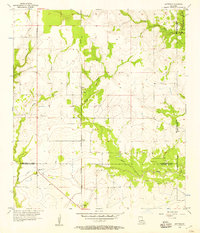
1956 Map of Gaytine
USGS Topo · Published 1957About this map
The Southern Pacific railroad corridor serves as the primary north-south artery through this mid-1950s landscape, connecting the small settlements of Gaytine, Turps, and Gillis. This area is defined by its complex waterway network and shifting parish boundaries, where Marsh Bayou and Indian Bayou snake through the terrain. The map captures a moment in Southwest Louisiana when industrial and transit infrastructure, including a prominent Radio Tower WT and a localized Canal, integrated with the natural drainage basins of Boggy Creek and Barnes Creek. Genealogists and local historians can trace the precise intersections of Beauregard, Allen, Calcasieu, and Jefferson Davis parishes as they stood during this survey period, providing a clear view of the regional geography before modern development altered these rural bayou communities.
Find a feature on this map
15 named features on this map. Tap any name to fly to it.
Don’t see what you’re looking for? This feature index may not catch every label — zoom into the map to look around manually.
Map Details
Editions of this 1956 Gaytine Map
2 editions found
Other maps of this area

1935 · Buhler
USGS Topo · 1:31,680

1935 · Moss Bluff
USGS Topo · 1:31,680

1935 · Gordon
USGS Topo · 1:31,680

1935 · Gaytine
USGS Topo · 1:31,680

1935 · Longville
USGS Topo · 1:31,680

1947 · Gaytine
USGS Topo · 1:31,680

1947 · Moss Bluff
USGS Topo · 1:31,680

1947 · Hecker
USGS Topo · 1:31,680

1947 · Kernan
USGS Topo · 1:31,680

1947 · Reeves
USGS Topo · 1:31,680