
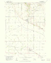
1957 Map of Gayville
USGS Topo · Published 1958About this map
The agrarian landscape of Yankton and Clay counties in the late 1950s is defined by a rigorous grid of section lines and the vital presence of dual rail lines. The Chicago and North Western and the Chicago Milwaukee St Paul and Pacific railroads dominate the southern and central sections of this survey, supporting the grain-handling and transportation needs of Volin and Gayville. Water management is a critical feature of this prairie terrain, evidenced by the Clay Creek Ditch and the extensive Levee systems designed to control the flow toward the Missouri River Basin.
Find a feature on this map
25 named features on this map. Tap any name to fly to it.
Don’t see what you’re looking for? This feature index may not catch every label — zoom into the map to look around manually.
Map Details
Editions of this 1957 Gayville Map
2 editions found
Other maps of this area

1898 · Parker
USGS Topo · 1:125,000

1955 · Sioux City
USGS Topo · 1:250,000

1955 · Sioux Falls
USGS Topo · 1:250,000

1957 · Mayfield
USGS Topo · 1:24,000

1957 · Mission Hill
USGS Topo · 1:24,000

1958 · Sioux City
USGS Topo · 1:250,000

1958 · Sioux Falls
USGS Topo · 1:250,000

1959 · Sioux City
USGS Topo · 1:250,000

1968 · St. Helena
USGS Topo · 1:24,000
1968 · Wakonda
USGS Topo · 1:24,000