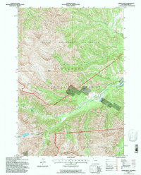
1991 Map of Geers Point
USGS Topo · Published 1997About this map
Lee City (Aband) sits as a silent vestige of late-nineteenth-century mining ambitions within the high elevations of Park County. This 1991 survey by the U.S. Forest Service documents the rugged drainage of Sunlight Creek, where geothermal activity is evidenced by several Thermal Areas and specialized mineral deposits. The landscape is dominated by steep topographical relief, rising toward the prominent Geers Point and extending into the North Absaroka Wilderness. Below the heights, Little Sunlight Creek and Sulphur Creek carve through the deep valleys of the Shoshone National Forest. Remote water features like Copper Lakes and Strawberry Gulch define the drainage patterns of this high-country terrain, while the Clarks Fork Rd provides the primary access route through the southern reaches of the quadrangle.
Find a feature on this map
19 named features on this map. Tap any name to fly to it.
Don’t see what you’re looking for? This feature index may not catch every label — zoom into the map to look around manually.
Map Details
Editions of this 1991 Geers Point Map
This is the sole edition of this map. No revisions or reprints were ever made.
Other maps of this area

1896 · Crandall Creek
USGS Topo · 1:125,000

1899 · Crandall
USGS Topo · 1:125,000

1955 · Cody
USGS Topo · 1:250,000

1956 · Sunlight Peak
USGS Topo · 1:62,500

1956 · Beartooth Butte
USGS Topo · 1:62,500

1956 · Pilot Peak
USGS Topo · 1:62,500

1956 · Dead Indian Peak
USGS Topo · 1:62,500

1958 · Cody
USGS Topo · 1:250,000

1962 · Cody
USGS Topo · 1:250,000

1980 · Cody
USGS Topo · 1:100,000