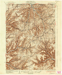
1937 Map of Genesee
USGS Topo · Published 1937About this map
The Allegheny River and the Genesee River both find their headwaters in this high divide of northern Pennsylvania during the 1930s. The landscape is defined by deep hollows and high ridges, where the New York and Pennsylvania RR and the Baltimore and Ohio RR follow the narrow valley floors to serve timber and agricultural outposts. Small hubs like Genesee and Ellisburg anchor the rural economy, while higher elevations host unique landmarks such as the Ice Mine and Ho-Wan-Ne Boy Scout Camp.
Find a feature on this map
72 named features on this map. Tap any name to fly to it.
Don’t see what you’re looking for? This feature index may not catch every label — zoom into the map to look around manually.
Map Details
Editions of this 1937 Genesee Map
3 editions found
Other maps of this area

1899 · Gaines
USGS Topo · 1:62,500

1900 · Gaines
USGS Topo · 1:62,500

1925 · Belmont
USGS Topo · 1:62,500

1926 · Wellsville
USGS Topo · 1:62,500

1926 · Greenwood
USGS Topo · 1:62,500

1932 · Genesee
USGS Topo · 1:62,500

1934 · Coudersport
USGS Topo · 1:48,000

1937 · Genesee
USGS Topo · 1:62,500

1938 · Coudersport
USGS Topo · 1:62,500

1939 · Belmont
USGS Topo · 1:62,500