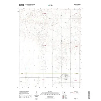
2018 Map of Geneseo
USGS Topo · Published 2018About this map
Geneseo anchors the southern portion of this central Kansas landscape, where the street grid of the town sits just north of the Little Arkansas River. The map documents a structured agricultural grid defined by numerous local roads like 16th Rd and Ave V, showing the organized expansion of Rice County. To the north, the small settlement of Midway marks a crossing point in the rolling terrain drained by a network of waterways, including Thompson Cr and Little Cow Cr. Genealogy researchers will find significant markers of the area's pioneer heritage at Kansas Center Cem in the west and Genesee Cem near the town site. The detailed street naming in Geneseo, featuring names like Moderwill Ave and Platt Ave, provides a clear view of the town's residential footprint near the county line with Ellsworth.
Find a feature on this map
42 named features on this map. Tap any name to fly to it.
Don’t see what you’re looking for? This feature index may not catch every label — zoom into the map to look around manually.
Map Details
Editions of this 2018 Geneseo Map
This is the sole edition of this map. No revisions or reprints were ever made.
Other maps of this area

1894 · Ellsworth
USGS Topo · 1:125,000

1894 · Lyons
USGS Topo · 1:125,000

1955 · Great Bend
USGS Topo · 1:250,000

1957 · Great Bend
USGS Topo · 1:250,000

1957 · Ellsworth
USGS Topo · 1:24,000
1957 · Carneiro
USGS Topo · 1:24,000

1957 · Holyrood NE
USGS Topo · 1:24,000

1958 · Great Bend
USGS Topo · 1:250,000
1964 · Crawford
USGS Topo · 1:24,000
1964 · Geneseo
USGS Topo · 1:24,000