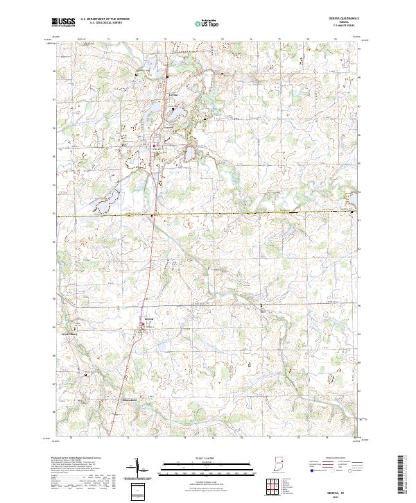
2022 Map of Geneva
USGS Topo · Published 2022About this map
Geneva serves as the primary hub in this portion of the northeastern Indiana landscape, situated near the winding path of the Wabash River and the historical Limberlost Cr. The map reveals a dense network of agricultural drainage, with named features such as Glendenning Ditch, Houser Ditch, and Leichty Ditch crisscrossing the terrain between the Adams Co Jay Co line. Small settlements and former rail stops like Ceylon, Bryant, and West Liberty are clearly identified, providing a detailed look at rural community placement. Genealogists will find significant value in the numerous burial grounds documented, including Westlawn Cem, Snow Cem, Collins Cem, and the Old Baptist Cem. The drainage patterns, particularly around Loblolly Creek and the many man-made ditches, reflect a century of efforts to reclaim and maintain this fertile farmland.
Find a feature on this map
85 named features on this map. Tap any name to fly to it.
Don’t see what you’re looking for? This feature index may not catch every label — zoom into the map to look around manually.
Map Details
Editions of this 2022 Geneva Map
This is the sole edition of this map. No revisions or reprints were ever made.
Other maps of this area

1911 · Berne
USGS Topo · 1:48,000

1915 · Fort Recovery
USGS Topo · 1:48,000

1918 · Fort Recovery
USGS Topo · 1:62,500

1953 · Muncie
USGS Topo · 1:250,000

1956 · Muncie
USGS Topo · 1:250,000

1960 · Fort Recovery
USGS Topo · 1:24,000

1960 · Blaine
USGS Topo · 1:24,000
1960 · Portland
USGS Topo · 1:24,000
1960 · New Corydon
USGS Topo · 1:24,000
1960 · Willshire
USGS Topo · 1:24,000