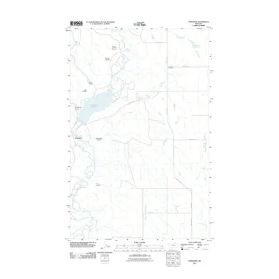
2011 Map of Genevieve
USGS Topo · Published 2011About this map
Genevieve (Historical) anchors this corner of Phillips County, where the high plains are carved by an intricate network of drainage coulees. The landscape is defined by the winding course of Frenchman Creek, which feeds into the Frenchman Reservoir, a significant water feature in an otherwise arid region. The geography reveals a ranching and agricultural orientation, with landmarks named for early settlers or natural features like Three Chimney Coulee, Bohner Coulee, and the curiously named Grandma Mogan height. To the west, the small community of Valleytown sits near the reservoir's edge, while the eastern section is marked by Nelsons Reservoir and the headwaters of the Middle Fork Cash Creek. The grid of local routes like Mogan Rd and Cache Creek Rd connects these isolated points across the rugged, coulee-cut terrain.
Find a feature on this map
21 named features on this map. Tap any name to fly to it.
Don’t see what you’re looking for? This feature index may not catch every label — zoom into the map to look around manually.
Map Details
Editions of this 2011 Genevieve Map
This is the sole edition of this map. No revisions or reprints were ever made.
Other maps of this area

1954 · Glasgow
USGS Topo · 1:250,000

1957 · Glasgow
USGS Topo · 1:250,000

1958 · Glasgow
USGS Topo · 1:250,000

1984 · Bjornberg Bridge
USGS Topo · 1:24,000

1984 · Snake Creek School
USGS Topo · 1:24,000

1984 · Double S Hill
USGS Topo · 1:24,000
1984 · Jones Coulee
USGS Topo · 1:24,000

1984 · Coulter Coulee
USGS Topo · 1:24,000

1984 · Dead Horse Coulee
USGS Topo · 1:24,000
1984 · Papoose Hills
USGS Topo · 1:24,000