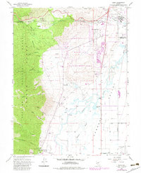
1968 Map of Genoa
USGS Topo · Published 1983About this map
The eastern slopes of the Toiyabe National Forest meet the valley floor in this 1968 Nevada survey. The settlement of Stewart and the Ormsby County Farm are prominent near the northern boundary, while the historic town of Genoa occupies the southwestern corner near the mouth of Genoa Canyon. The landscape is defined by the transitions between the steep canyon reaches, such as Schoolhouse Canyon and James Canyon, and the irrigated agricultural lands of the Carson River valley. To the north, Jacks Valley is shown during its management as a wildlife area, with numerous springs and the Hobo Hot Springs feeding into the basin. The map records the complex network of water management through features like the Carson Slough and various ditches and aqueducts that supported the local ranching and farming economy in Douglas County.
Find a feature on this map
2 named features on this map. Tap any name to fly to it.
Don’t see what you’re looking for? This feature index may not catch every label — zoom into the map to look around manually.
Map Details
Editions of this 1968 Genoa Map
3 editions found
Other maps of this area

1889 · Markleeville
USGS Topo · 1:125,000

1891 · Carson
USGS Topo · 1:125,000

1891 · Markleeville
USGS Topo · 1:125,000

1893 · Carson
USGS Topo · 1:125,000

1893 · Markleeville
USGS Topo · 1:125,000

1948 · Walker Lake
USGS Topo · 1:250,000

1955 · Bijou
USGS Topo · 1:24,000

1955 · Marlette Lake
USGS Topo · 1:24,000

1955 · Glenbrook
USGS Topo · 1:24,000

1956 · Freel Peak
USGS Topo · 1:62,500