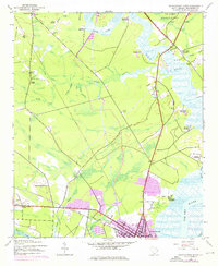
1943 Map of Georgetown North
USGS Topo · Published 1976About this map
The confluence of the Black River, Pee Dee River, and Waccamaw River defines the landscape just north of Georgetown, illustrating the transition from traditional river-fronting estates to mid-century industrial growth. Numerous historic landholdings line the riverbanks, including Lark Hill Plantation, Mansfield Plantation, and Kensington Plantation, marking the legacy of the region's agricultural past. While the 1943 topography reflects established patterns of drainage and swamp land, 1973 revisions in purple highlight the northward expansion of the city's residential and commercial footprint.
Find a feature on this map
48 named features on this map. Tap any name to fly to it.
Don’t see what you’re looking for? This feature index may not catch every label — zoom into the map to look around manually.
Map Details
Editions of this 1943 Georgetown North Map
3 editions found
Other maps of this area

1942 · North Island
USGS Topo · 1:24,000

1942 · Waverly Mills
USGS Topo · 1:24,000

1943 · Olin
USGS Topo · 1:31,680

1943 · Carvers Bay
USGS Topo · 1:24,000

1943 · Plantersville
USGS Topo · 1:24,000

1943 · Kilsock Bay
USGS Topo · 1:24,000

1943 · Rhems
USGS Topo · 1:24,000

1943 · Georgetown North
USGS Topo · 1:24,000

1943 · Georgetown South
USGS Topo · 1:24,000

1947 · Georgetown South
USGS Topo · 1:24,000