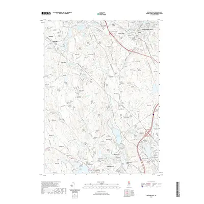
2021 Map of Georgiaville
USGS Topo · Published 2021About this map
The Woonasquatucket River and Branch River systems define this northern Rhode Island landscape, anchoring a network of industrial-era mill villages and reservoirs. Settlements like Slatersville, Forestdale, and Georgiaville show the dense development characteristic of the Blackstone Valley's manufacturing legacy. The map is particularly notable for its high concentration of family burial plots and colonial-era cemeteries, including the Old Town Burial Ground, the Old Aldrich Burial Grounds, and numerous smaller sites like the Mowry Sales Lot Cem and Aldrich Staples Lot Cem. These features, alongside landmarks like The Blunders and Nipsachuck Hill, provide a detailed view of how the region's topography influenced its settlement. Modern institutions, such as Bryant University, sit adjacent to older infrastructure like the Stillwater Reservoir and the Capron Memorial Bridge, illustrating the layering of academic growth over a deep-rooted hydraulic and agricultural history.
Find a feature on this map
162 named features on this map. Tap any name to fly to it.
Don’t see what you’re looking for? This feature index may not catch every label — zoom into the map to look around manually.
Map Details
Editions of this 2021 Georgiaville Map
This is the sole edition of this map. No revisions or reprints were ever made.
Other maps of this area

1886 · Blackstone
USGS Topo · 1:62,500

1887 · Franklin
USGS Topo · 1:62,500

1887 · Providence
USGS Topo · 1:62,500

1889 · Providence
USGS Topo · 1:62,500

1889 · Blackstone
USGS Topo · 1:62,500

1889 · Franklin
USGS Topo · 1:62,500

1889 · Burrillville
USGS Topo · 1:62,500

1893 · Franklin
USGS Topo · 1:62,500

1893 · Blackstone
USGS Topo · 1:62,500

1894 · Burrillville
USGS Topo · 1:62,500