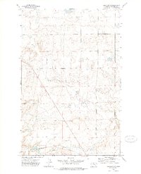
1972 Map of Geraldine NE
USGS Topo · Published 1976About this map
Chicago Milwaukee St Paul and Pacific railroad tracks cross the southern reaches of this Chouteau County landscape, illustrating the vital role of heavy rail in connecting Montana's agricultural interior during the early 1970s. The terrain is defined by the drainage patterns of Mud Spring Coulee, which winds through the central portion of the map. This area, surveyed by photogrammetric methods from 1971 aerial photographs, shows a sparsely populated region primarily characterized by its natural water features like the simple Spring found nestled in the northern coulee system. The map serves as a precise record of the land surface before further modern developments, highlighting the stark relief and the isolation of the northern Great Plains ranching country.
Find a feature on this map
3 named features on this map. Tap any name to fly to it.
Don’t see what you’re looking for? This feature index may not catch every label — zoom into the map to look around manually.
Map Details
Editions of this 1972 Geraldine NE Map
This is the sole edition of this map. No revisions or reprints were ever made.
Other maps of this area

1890 · Fort Benton
USGS Topo · 1:250,000

1892 · Fort Benton
USGS Topo · 1:250,000

1897 · Fort Benton
USGS Topo · 1:250,000

1953 · Rocky Lake
USGS Topo · 1:24,000

1954 · Great Falls
USGS Topo · 1:250,000

1957 · Great Falls
USGS Topo · 1:250,000
1972 · Eagle Buttes SW
USGS Topo · 1:24,000

1972 · Square Butte
USGS Topo · 1:24,000
1972 · Stranahan SE
USGS Topo · 1:24,000
1972 · Montague
USGS Topo · 1:24,000