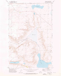
1972 Map of Montague
USGS Topo · Published 1976About this map
Montague serves as the central hub of this Chouteau County landscape, positioned along the tracks of the Chicago Milwaukee St Paul and Pacific railroad. The presence of Grain Elevators and multiple Storage Bins scattered across the plains highlights the agricultural importance of the region during the early 1970s. This survey records the essential infrastructure that supported local grain production and transport during a period when rail lines remained vital to the rural Montana economy.
Find a feature on this map
11 named features on this map. Tap any name to fly to it.
Don’t see what you’re looking for? This feature index may not catch every label — zoom into the map to look around manually.
Map Details
Editions of this 1972 Montague Map
This is the sole edition of this map. No revisions or reprints were ever made.
Other maps of this area

1890 · Fort Benton
USGS Topo · 1:250,000

1892 · Fort Benton
USGS Topo · 1:250,000

1897 · Fort Benton
USGS Topo · 1:250,000

1953 · Rocky Lake
USGS Topo · 1:24,000

1953 · O'Hanlon Coulee
USGS Topo · 1:24,000

1954 · Great Falls
USGS Topo · 1:250,000

1957 · Great Falls
USGS Topo · 1:250,000
1972 · Stranahan SE
USGS Topo · 1:24,000
1972 · Shonkin
USGS Topo · 1:24,000
1972 · Geraldine NE
USGS Topo · 1:24,000