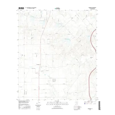
2016 Map of Geronimo
USGS Topo · Published 2016About this map
Geronimo sits at the heart of this landscape, where the prairie of the Guadalupe Valley meets the rising elevations of Harborth Hill and Hermann Hill. The 2016 survey documents a rural landscape managed by water conservation efforts, evidenced by several reservoirs such as Soil Conservation Service Site 8 Reservoir and Soil Conservation Service Site 11 Reservoir. These sites help regulate the flow of York Cr and Geronimo Cr, which drain the surrounding agricultural lands. Cultural history is anchored by family-named landmarks and resting places, including San Juan Cem near the town center and the Wade Cem located further north near Galle. The proximity of Moltz Airport and the development around Mill Creek Hills reflect the gradual shift toward residential and light aviation use while maintaining the area's agrarian roots.
Find a feature on this map
78 named features on this map. Tap any name to fly to it.
Don’t see what you’re looking for? This feature index may not catch every label — zoom into the map to look around manually.
Map Details
Editions of this 2016 Geronimo Map
This is the sole edition of this map. No revisions or reprints were ever made.
Other maps of this area
1911 · San Marcos
USGS Topo · 1:125,000
1919 · San Marcos
USGS Topo · 1:125,000
1924 · New Braunfels No 4
USGS Topo · 1:48,000
1924 · San Marcos 3-c
USGS Topo · 1:48,000
1924 · San Marcos 3-d
USGS Topo · 1:48,000
1925 · New Braunfels No 1
USGS Topo · 1:48,000
1927 · New Braunfels
USGS Topo · 1:62,500
1929 · Hunter
USGS Topo · 1:62,500
1930 · Seguin
USGS Topo · 1:62,500

1953 · Seguin
USGS Topo · 1:250,000