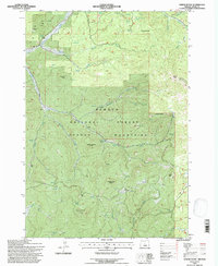
1992 Map of Gerow Butte
USGS Topo · Published 1997About this map
Ochoco National Forest defines the character of this high-elevation landscape, where the Ochoco Mountains rise over the terrain of eastern Crook County. The 1992 survey reveals a history of resource extraction concentrated in the northwest corner, where an Open Pit Mine, Mine Tunnel, and various Prospects suggest local mineral interest near Ochoco Creek. The geography is shaped by numerous high points including Duncan Butte, Hawkins Butte, and the prominent Gerow Butte, which features a Lookout station at its summit. Water sources are critical in this environment, marked by a dense network of springs such as Douthit Spring, Crooked Tree Spring, and Gerow Spring. The presence of the Nelson Monument in the southeast adds a unique historical marker to this forested interior.
Find a feature on this map
40 named features on this map. Tap any name to fly to it.
Don’t see what you’re looking for? This feature index may not catch every label — zoom into the map to look around manually.
Map Details
Editions of this 1992 Gerow Butte Map
This is the sole edition of this map. No revisions or reprints were ever made.
Other maps of this area

1946 · Eagle Rock
USGS Topo · 1:62,500

1948 · Eagle Rock
USGS Topo · 1:62,500

1948 · Ochoco Reservoir
USGS Topo · 1:62,500

1950 · Ochoco Reservoir
USGS Topo · 1:62,500

1951 · Post
USGS Topo · 1:62,500

1951 · Lookout Mtn
USGS Topo · 1:62,500

1955 · Bend
USGS Topo · 1:250,000

1957 · Bend
USGS Topo · 1:250,000

1958 · Bend
USGS Topo · 1:250,000

1981 · Prineville
USGS Topo · 1:100,000