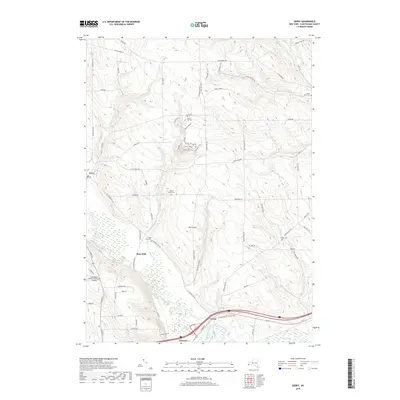
2019 Map of Gerry
USGS Topo · Published 2019About this map
Cassadaga Creek flows through the heart of this Chautauqua County landscape, winding past the village of Gerry and the settlement of Ross Mills. The terrain north of Harris Hill is marked by a series of humorously named ridges including Humpty Dumpty, Rib Tickler, and Myrtle's Romp, suggesting a local vernacular for the undulating topography between Hatch Cr and Twentyeighth Cr. In the southern portion of the map, the industrial and transport footprint expands near Falconer and Levant, where the Chadakoin River joins the creek system. Genealogists will find a high density of burial sites preserved here, from the Gerry Hill Cem in the north to the Levant Cem and Ross Mills Cem further south. The presence of the Chautauqua County/Jamestown Airport signifies the modern infrastructure serving the nearby regional hub.
Find a feature on this map
78 named features on this map. Tap any name to fly to it.
Don’t see what you’re looking for? This feature index may not catch every label — zoom into the map to look around manually.
Map Details
Editions of this 2019 Gerry Map
This is the sole edition of this map. No revisions or reprints were ever made.
Other maps of this area

1900 · Dunkirk
USGS Topo · 1:62,500

1900 · Cherry Creek
USGS Topo · 1:62,500

1904 · Chautaqua
USGS Topo · 1:62,500

1905 · Jamestown
USGS Topo · 1:62,500

1941 · Cherry Creek
USGS Topo · 1:62,500

1941 · Chautauqua
USGS Topo · 1:62,500

1942 · Jamestown
USGS Topo · 1:62,500

1943 · Dunkirk
USGS Topo · 1:62,500
1954 · Kennedy
USGS Topo · 1:24,000

1954 · Ellery Center
USGS Topo · 1:24,000