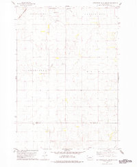
1978 Map of Gettysburg Muni. Airport
USGS Topo · Published 1978About this map
Gettysburg Municipal Airport sits at the northern edge of this Dakota landscape, marking the transition from the municipal boundaries of Gettysburg into the surrounding agricultural townships of Cunningham and Owattonna. The terrain is defined by the gradual descent toward several drainage systems, notably Artichoke Creek in the north and the headwaters of Okobojo Cr near the southern settlement of Okobojo.
Find a feature on this map
16 named features on this map. Tap any name to fly to it.
Don’t see what you’re looking for? This feature index may not catch every label — zoom into the map to look around manually.
Map Details
Editions of this 1978 Gettysburg Muni. Airport Map
This is the sole edition of this map. No revisions or reprints were ever made.
Other maps of this area

1953 · Huron
USGS Topo · 1:250,000

1953 · McIntosh
USGS Topo · 1:250,000

1954 · Aberdeen
USGS Topo · 1:250,000

1954 · Pierre
USGS Topo · 1:250,000

1954 · Huron
USGS Topo · 1:250,000

1956 · Aberdeen
USGS Topo · 1:250,000

1958 · Pierre
USGS Topo · 1:250,000

1958 · McIntosh
USGS Topo · 1:250,000

1965 · Agar
USGS Topo · 1:24,000
1970 · Agar NE
USGS Topo · 1:24,000