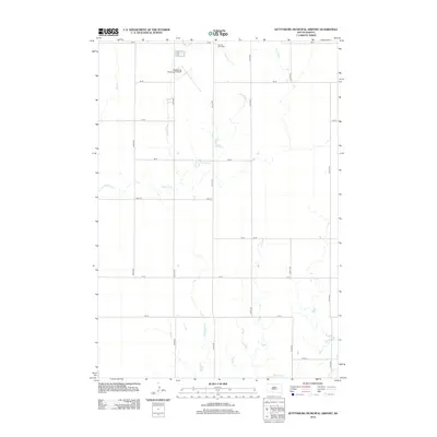
2012 Map of Gettysburg Municipal Airport
USGS Topo · Published 2012About this map
Artichoke Creek meanders through this agricultural landscape in Potter County, where the sprawling grid of the South Dakota prairie is defined by section-line roads like 165 St and 309th Ave. This survey of the rural surroundings of Gettysburg is anchored by the Gettysburg Municipal Airport in the northern section, adjacent to the Sacred Heart Cemetery. The landscape is largely defined by its drainage patterns, with the northern reaches feeding into the Artichoke system while the southern section is home to Okobojo Creek. The map provides a clear look at the late 20th and early 21st-century rural infrastructure, including a dense network of numbered avenues and streets that facilitate the region's expansive farming operations.
Find a feature on this map
19 named features on this map. Tap any name to fly to it.
Don’t see what you’re looking for? This feature index may not catch every label — zoom into the map to look around manually.
Map Details
Editions of this 2012 Gettysburg Municipal Airport Map
This is the sole edition of this map. No revisions or reprints were ever made.
Other maps of this area

1953 · Huron
USGS Topo · 1:250,000

1953 · McIntosh
USGS Topo · 1:250,000

1954 · Aberdeen
USGS Topo · 1:250,000

1954 · Pierre
USGS Topo · 1:250,000

1954 · Huron
USGS Topo · 1:250,000

1956 · Aberdeen
USGS Topo · 1:250,000

1958 · Pierre
USGS Topo · 1:250,000

1958 · McIntosh
USGS Topo · 1:250,000

1965 · Agar
USGS Topo · 1:24,000
1970 · Agar NE
USGS Topo · 1:24,000