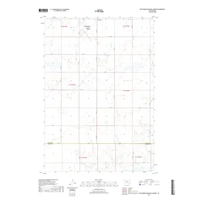
2017 Map of Gettysburg Municipal Airport
USGS Topo · Published 2017About this map
Gettysburg Municipal Airport serves as a prominent landmark on this South Dakota landscape, situated just south of the Sacred Heart Cem at the northern edge of the survey. The terrain is defined by the winding paths of Artichoke Cr and Okobojo Cr, which carve through the plains and create distinct drainage patterns across the township boundaries of T118N and T117N. A strictly surveyed grid of county roads, including Co RD 816 and 311th Ave, segments the land into traditional agricultural sections. Along the southern reaches of the map, the Potter Co Sully Co line marks the political transition between counties, where the land begins to slope toward the Okobojo drainage system. The map captures the specialized rural infrastructure of the region, where aviation, cemetery grounds, and section-line roads intersect with the natural hydrology of the Missouri River plateau.
Find a feature on this map
31 named features on this map. Tap any name to fly to it.
Don’t see what you’re looking for? This feature index may not catch every label — zoom into the map to look around manually.
Map Details
Editions of this 2017 Gettysburg Municipal Airport Map
This is the sole edition of this map. No revisions or reprints were ever made.
Other maps of this area

1953 · Huron
USGS Topo · 1:250,000

1953 · McIntosh
USGS Topo · 1:250,000

1954 · Aberdeen
USGS Topo · 1:250,000

1954 · Pierre
USGS Topo · 1:250,000

1954 · Huron
USGS Topo · 1:250,000

1956 · Aberdeen
USGS Topo · 1:250,000

1958 · Pierre
USGS Topo · 1:250,000

1958 · McIntosh
USGS Topo · 1:250,000

1965 · Agar
USGS Topo · 1:24,000
1970 · Agar NE
USGS Topo · 1:24,000