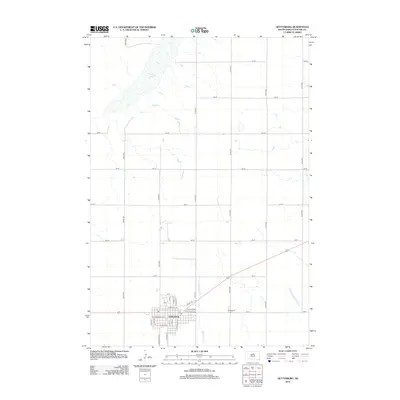
2012 Map of Gettysburg
USGS Topo · Published 2012About this map
Gettysburg serves as the primary hub of this Potter County landscape, organized by a precise grid of residential streets and agricultural sections. The town's layout is defined by major thoroughfares such as W Commercial Ave and E Railway Ave, reflecting the historical influence of the rail corridor on the local economy. To the northeast, the terrain is marked by Green Lake, a significant water feature in an otherwise strictly partitioned prairie. The drainage of Artichoke Cr meanders southward past the eastern edge of the settlement, providing a natural contrast to the geometric precision of the surrounding section roads. On the southern outskirts of the community, the Gettysburg Cem provides a focal point for genealogical interest, situated near the intersection of the town's expanding southern reaches and the open fields of the Dakotas.
Find a feature on this map
36 named features on this map. Tap any name to fly to it.
Don’t see what you’re looking for? This feature index may not catch every label — zoom into the map to look around manually.
Map Details
Editions of this 2012 Gettysburg Map
This is the sole edition of this map. No revisions or reprints were ever made.
Other maps of this area

1953 · Huron
USGS Topo · 1:250,000

1953 · McIntosh
USGS Topo · 1:250,000

1954 · Aberdeen
USGS Topo · 1:250,000

1954 · Pierre
USGS Topo · 1:250,000

1954 · Huron
USGS Topo · 1:250,000

1956 · Aberdeen
USGS Topo · 1:250,000

1958 · Pierre
USGS Topo · 1:250,000

1958 · McIntosh
USGS Topo · 1:250,000

1970 · Lake Hurley NE
USGS Topo · 1:24,000
1970 · Agar NE
USGS Topo · 1:24,000