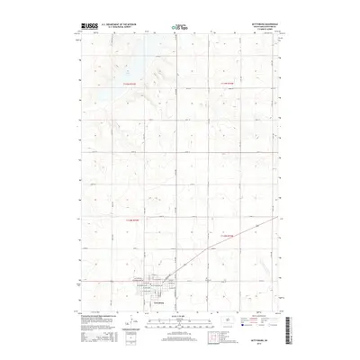
2015 Map of Gettysburg
USGS Topo · Published 2015About this map
Gettysburg serves as the focal point of this South Dakota prairie landscape, situated at the crossroads of a grid-defined agricultural region. The town's layout is clearly delineated by streets such as N Main St, E Garfield Ave, and W Custer Ave, radiating from the central core. To the northeast, Gettysburg Cem provides a point of genealogical interest, while Green Lake is the primary water feature in the otherwise dry uplands. The terrain is defined by the Public Land Survey System, with township boundaries like t118n r76w and t119n r75w marking the organized expansion of Potter County. The map captures the infrastructure of a modern rural hub, where a dense network of numbered section-line roads, including 164th St and 311th Ave, connects remote farmsteads to the commercial and civic heart of the community.
Find a feature on this map
41 named features on this map. Tap any name to fly to it.
Don’t see what you’re looking for? This feature index may not catch every label — zoom into the map to look around manually.
Map Details
Editions of this 2015 Gettysburg Map
This is the sole edition of this map. No revisions or reprints were ever made.
Other maps of this area
1953 · Huron
USGS Topo · 1:250,000
1953 · McIntosh
USGS Topo · 1:250,000
1954 · Aberdeen
USGS Topo · 1:250,000
1954 · Pierre
USGS Topo · 1:250,000
1954 · Huron
USGS Topo · 1:250,000
1956 · Aberdeen
USGS Topo · 1:250,000
1958 · Pierre
USGS Topo · 1:250,000
1958 · McIntosh
USGS Topo · 1:250,000
1970 · Lake Hurley NE
USGS Topo · 1:24,000
1970 · Agar NE
USGS Topo · 1:24,000