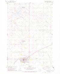
1978 Map of Gettysburg
USGS Topo · Published 1978About this map
The town of Gettysburg serves as the focal point of this Potter County survey, situated at the junction of the Chicago and North Western railroad and local highway routes. The map illustrates a well-developed prairie community featuring a centralized Park, a local Golf Course, and the expansive Fairground on the northern edge of the settlement. To the east, the Drive-in Theater and Gettysburg Cemetery along the drainage of Artichoke Creek mark the transition from the town grid to the surrounding rural townships of Cunningham and Gettysburg.
Find a feature on this map
20 named features on this map. Tap any name to fly to it.
Don’t see what you’re looking for? This feature index may not catch every label — zoom into the map to look around manually.
Map Details
Editions of this 1978 Gettysburg Map
This is the sole edition of this map. No revisions or reprints were ever made.
Other maps of this area

1953 · Huron
USGS Topo · 1:250,000

1953 · McIntosh
USGS Topo · 1:250,000

1954 · Aberdeen
USGS Topo · 1:250,000

1954 · Pierre
USGS Topo · 1:250,000

1954 · Huron
USGS Topo · 1:250,000

1956 · Aberdeen
USGS Topo · 1:250,000

1958 · Pierre
USGS Topo · 1:250,000

1958 · McIntosh
USGS Topo · 1:250,000

1970 · Lake Hurley NE
USGS Topo · 1:24,000
1970 · Agar NE
USGS Topo · 1:24,000