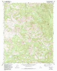
1965 Map of Gibbon Peak
USGS Topo · Published 1994About this map
The Tule River Indian Reservation dominates the northern portion of this landscape, where high peaks and deep canyons define the transition from the valley floor to the Sierra foothills. In the mid-1960s, this area remained largely undeveloped, characterized by seasonal water sources and a network of unimproved tracks like Whiggletail Road and Pothole Road. High points such as Gibbon Peak and Buck Peak tower over the drainage basins of Deer Creek and Gordon Creek. Evidence of early land use is scattered throughout the terrain, including a Mine and a small Cem near Galley Mtn. The prevalence of named springs and wells across the quadrangle, including Fountain Springs and the distinctive geological feature known as The Pothole, highlights the critical importance of water management in this arid Tulare County environment.
Find a feature on this map
26 named features on this map. Tap any name to fly to it.
Don’t see what you’re looking for? This feature index may not catch every label — zoom into the map to look around manually.
Map Details
Editions of this 1965 Gibbon Peak Map
3 editions found
Other maps of this area

1904 · Kaweah
USGS Topo · 1:125,000

1909 · Kaweah
USGS Topo · 1:125,000

1926 · Quincy School
USGS Topo · 1:31,680

1929 · Quincy School
USGS Topo · 1:31,680

1936 · White River
USGS Topo · 1:62,500

1936 · Tobias Peak
USGS Topo · 1:125,000

1937 · Kaweah
USGS Topo · 1:125,000

1943 · Tobias Peak
USGS Topo · 1:125,000

1945 · Tobias Peak
USGS Topo · 1:62,500

1948 · Bakersfield
USGS Topo · 1:250,000