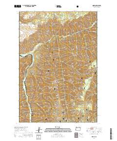
2020 Map of Gibbon
USGS Topo · Published 2020About this map
Gibbon sits at the confluence of the Umatilla River and Meacham Cr, serving as a focal point for this section of the Blue Mountains. The landscape is defined by its dramatic topographic relief, featuring prominent elevations such as Wildhorse Mtn and Reservation Mtn to the north, while the southern portion of the sheet is dominated by the Umatilla National Forest. The map reveals a complex network of ridgelines and drainages, with evocative local names like Starve-to-Death Ridge, Boston Canyon, and Rattlesnake Ridge. These features reflect the region's history of grazing, timber, and difficult passage. Water sources such as Thompson Spring and Rock Spring are critical markers in this arid high-country terrain, connected by rural routes including Bingham Rd and the Meacham Creek Rd.
Find a feature on this map
34 named features on this map. Tap any name to fly to it.
Don’t see what you’re looking for? This feature index may not catch every label — zoom into the map to look around manually.
Map Details
Editions of this 2020 Gibbon Map
This is the sole edition of this map. No revisions or reprints were ever made.
Other maps of this area

1953 · Pendleton
USGS Topo · 1:250,000

1956 · Pendleton
USGS Topo · 1:250,000

1963 · Bingham Springs
USGS Topo · 1:24,000

1963 · Blalock Mountain
USGS Topo · 1:24,000

1964 · Thorn Hollow
USGS Topo · 1:24,000

1964 · Athena
USGS Topo · 1:24,000

1964 · Weston Mountain
USGS Topo · 1:24,000

1964 · Duncan
USGS Topo · 1:24,000

1964 · Thimbleberry Mtn
USGS Topo · 1:24,000

1964 · Gibbon
USGS Topo · 1:24,000