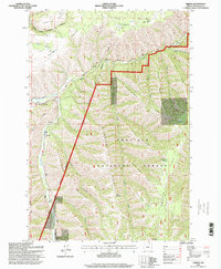
1995 Map of Gibbon
USGS Topo · Published 1998About this map
Gibbon sits at the convergence of mountain ridges and the winding Umatilla River, marking a point where tribal lands and federal forests meet. This 1990s revision by the U.S. Forest Service traces the complex geography of the Umatilla Indian Reservation Boundary as it cuts across the northern slopes of Wildhorse Mountain. The landscape is defined by its dramatic relief, with evocative names like Starve-to-Death Ridge and Plenty Bear Ridge hinting at the traditional knowledge and history of the Blue Mountains region.
Find a feature on this map
26 named features on this map. Tap any name to fly to it.
Don’t see what you’re looking for? This feature index may not catch every label — zoom into the map to look around manually.
Map Details
Editions of this 1995 Gibbon Map
This is the sole edition of this map. No revisions or reprints were ever made.
Other maps of this area

1953 · Pendleton
USGS Topo · 1:250,000

1956 · Pendleton
USGS Topo · 1:250,000

1963 · Bingham Springs
USGS Topo · 1:24,000

1963 · Blalock Mountain
USGS Topo · 1:24,000

1964 · Thorn Hollow
USGS Topo · 1:24,000

1964 · Athena
USGS Topo · 1:24,000

1964 · Weston Mountain
USGS Topo · 1:24,000

1964 · Duncan
USGS Topo · 1:24,000

1964 · Thimbleberry Mtn
USGS Topo · 1:24,000

1964 · Gibbon
USGS Topo · 1:24,000