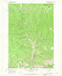
1966 Map of Gibbonsville
USGS Topo · Published 1971About this map
Gibbonsville sits along the narrow valley of the North Fork Salmon River in this mid-1960s survey of the Idaho-Montana border. The landscape is defined by the steep canyon walls of the Salmon National Forest and Beaverhead National Forest, meeting at the Continental Divide. A legacy of mining is evident throughout the terrain, from the tailings and mines near Cyanide Gulch to the numerous prospects scattered along Dahlonega Creek. The historic passage through this mountain corridor is preserved by the marking of the Lewis and Clark Trail, which follows the river's path alongside a Historical Monument. Further north, recreation and forestry infrastructure appear at the Twin Creek Campground and various pack trails ascending toward Anderson Mountain.
Find a feature on this map
59 named features on this map. Tap any name to fly to it.
Don’t see what you’re looking for? This feature index may not catch every label — zoom into the map to look around manually.
Map Details
Editions of this 1966 Gibbonsville Map
4 editions found
Other maps of this area

1955 · Dillon
USGS Topo · 1:250,000

1956 · Elk City
USGS Topo · 1:250,000

1957 · Dillon
USGS Topo · 1:250,000

1958 · Dillon
USGS Topo · 1:250,000

1960 · Elk City
USGS Topo · 1:250,000

1960 · Ulysses Mtn
USGS Topo · 1:62,500

1960 · Piquett Mountain
USGS Topo · 1:62,500

1962 · Dillon
USGS Topo · 1:250,000

1965 · Dillon
USGS Topo · 1:250,000

1966 · Lost Trail Pass
USGS Topo · 1:24,000