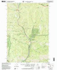
1997 Map of Gibbonsville
USGS Topo · Published 2002About this map
Gibbonsville serves as the focal point of this mountain landscape at the turn of the 21st century, situated where Dahlonega Creek meets the North Fork Salmon River. The map documents a geography defined by traditional mining and transit, with numerous prospects and mines dotting the gulches and specific industrial labels like Cyanide and River Tailings near the town center. The area's deep historical layers are evident in the overlapping paths of the Lewis and Clark Trail, the Nez Perce Trail, and the Continental Divide National Scenic Trail, which all converge near Big Hole Pass on the Continental Divide. From the Granite Mountain Guard Station to the Historical Monument, the map traces the intersection of resource extraction and preservation within the Salmon National Forest.
Find a feature on this map
59 named features on this map. Tap any name to fly to it.
Don’t see what you’re looking for? This feature index may not catch every label — zoom into the map to look around manually.
Map Details
Editions of this 1997 Gibbonsville Map
This is the sole edition of this map. No revisions or reprints were ever made.
Other maps of this area

1955 · Dillon
USGS Topo · 1:250,000

1956 · Elk City
USGS Topo · 1:250,000

1957 · Dillon
USGS Topo · 1:250,000

1958 · Dillon
USGS Topo · 1:250,000

1960 · Elk City
USGS Topo · 1:250,000

1960 · Ulysses Mtn
USGS Topo · 1:62,500

1960 · Piquett Mountain
USGS Topo · 1:62,500

1962 · Dillon
USGS Topo · 1:250,000

1965 · Dillon
USGS Topo · 1:250,000

1966 · Lost Trail Pass
USGS Topo · 1:24,000