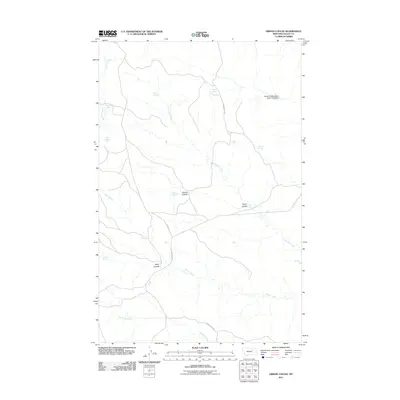
2011 Map of Gibson Coulee
USGS Topo · Published 2011About this map
Sutherland Creek and Plum Creek define the drainage patterns of this Valley County landscape, where the high plains of Montana are etched by numerous named coulees and intermittent water sources. The map records a series of springs that likely served as critical water points for early ranching operations, including Chittick Spring, Haney Spring, and Andys Spring. These features, alongside Gibson Coulee and Taylor Coulee, illustrate the localized geography that dictated movement and settlement in this semi-arid region. Transportation is primarily limited to secondary routes like Stonehouse Rd and Harper Ridge Rd, which follow the higher ground between creek beds. The inclusion of the Willow Creek Upper South Fork Dam in the northeast indicates modern water management efforts in an area otherwise dominated by the natural meanders of Square Creek and Carpenter Creek.
Find a feature on this map
19 named features on this map. Tap any name to fly to it.
Don’t see what you’re looking for? This feature index may not catch every label — zoom into the map to look around manually.
Map Details
Editions of this 2011 Gibson Coulee Map
This is the sole edition of this map. No revisions or reprints were ever made.
Other maps of this area

1954 · Jordan
USGS Topo · 1:250,000

1956 · Jordan
USGS Topo · 1:250,000

1958 · Jordan
USGS Topo · 1:250,000

1964 · Jordan
USGS Topo · 1:250,000

1971 · Wolfe Coulee
USGS Topo · 1:24,000

1971 · Wagon Coulee
USGS Topo · 1:24,000

1971 · Harper Camp
USGS Topo · 1:24,000
1973 · Triple Crossing Reservoir East
USGS Topo · 1:24,000

1973 · Triple Crossing Reservoir West
USGS Topo · 1:24,000

1973 · Niles Coulee
USGS Topo · 1:24,000