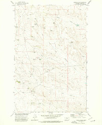
1973 Map of Gibson Coulee
USGS Topo · Published 1977About this map
Chittick Spring and Andy Spring anchor a high desert landscape in Valley County, mapped during the early 1970s for the Missouri River Basin development program. This map reveals a complex network of ephemeral drainages and named coulees, such as Gibson Coulee and Taylor Coulee, which define the local drainage patterns. The territory is marked by numerous family-named and descriptive water sources, including Half Moon Spring, Haney Spring, and Wagner Spring, illustrating the vital importance of dependable water points in this arid region. The drainage systems of Square Creek and Sutherland Creek wind through the terrain, while the southern portion of the sheet is dominated by the course of Plum Creek and its tributary, Carpenter Spr Creek. These features collectively document the hydrologic character of the eastern Montana plains before modern modifications.
Find a feature on this map
19 named features on this map. Tap any name to fly to it.
Don’t see what you’re looking for? This feature index may not catch every label — zoom into the map to look around manually.
Map Details
Editions of this 1973 Gibson Coulee Map
This is the sole edition of this map. No revisions or reprints were ever made.
Other maps of this area

1954 · Jordan
USGS Topo · 1:250,000

1956 · Jordan
USGS Topo · 1:250,000

1958 · Jordan
USGS Topo · 1:250,000

1964 · Jordan
USGS Topo · 1:250,000

1971 · Wolfe Coulee
USGS Topo · 1:24,000

1971 · Wagon Coulee
USGS Topo · 1:24,000

1971 · Harper Camp
USGS Topo · 1:24,000
1973 · Triple Crossing Reservoir East
USGS Topo · 1:24,000

1973 · Triple Crossing Reservoir West
USGS Topo · 1:24,000

1973 · Niles Coulee
USGS Topo · 1:24,000