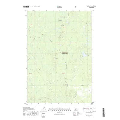
2020 Map of Gifford Peak
USGS Topo · Published 2020About this map
Indian Heaven dominates this portion of the Gifford Pinchot National Forest, a high-elevation plateau characterized by a dense concentration of small alpine lakes and volcanic landforms. The Pacific Crest National Scenic Trail traverses the center of the sheet, passing near Gifford Peak and Berry Mtn. This landscape is fundamentally shaped by its volcanic history, evidenced by the expansive Big Lava Bed in the southeast and prominent vents like East Crater. A network of historic routes, including the Indian Racetrack and the Thomas Lake Trail, connects numerous water bodies such as Lake Umtux, Lake Sahalee Tyee, and the Forlorn Lakes. To the south, the terrain descends toward Carson Guler, while the western edge is defined by the headwaters of Upper Falls Creek and McClellan Meadows.
Find a feature on this map
46 named features on this map. Tap any name to fly to it.
Don’t see what you’re looking for? This feature index may not catch every label — zoom into the map to look around manually.
Map Details
Editions of this 2020 Gifford Peak Map
This is the sole edition of this map. No revisions or reprints were ever made.
Other maps of this area

1926 · Steamboat Mtn
USGS Topo · 1:125,000

1926 · Hood River
USGS Topo · 1:125,000

1929 · Hood River
USGS Topo · 1:125,000

1931 · Steamboat Mtn
USGS Topo · 1:125,000

1950 · Yakima
USGS Topo · 1:250,000

1953 · The Dalles
USGS Topo · 1:250,000

1956 · The Dalles
USGS Topo · 1:250,000

1957 · The Dalles
USGS Topo · 1:250,000

1957 · Wind River
USGS Topo · 1:62,500

1957 · Willard
USGS Topo · 1:62,500