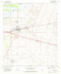
1973 Map of Gila Bend
USGS Topo · Published 1976About this map
Gila Bend serves as a critical desert junction in the early 1970s, defined by the convergence of the Southern Pacific railroad and major roadways like U.S. Highway 80. The town is surrounded by a complex landscape of military and tribal lands, including the Gila Bend Indian Reservation to the north and the expansive Luke Air Force Range to the south. Local history is anchored in sites such as San Lucy Village and several burial grounds, including Pioneer Cem and Stout Cem, reflecting generations of settlement along the Gila River corridor.
Find a feature on this map
43 named features on this map. Tap any name to fly to it.
Don’t see what you’re looking for? This feature index may not catch every label — zoom into the map to look around manually.
Map Details
Editions of this 1973 Gila Bend Map
2 editions found
Other maps of this area

1950 · Theba
USGS Topo · 1:62,500

1951 · Gila Bend
USGS Topo · 1:62,500

1951 · Theba
USGS Topo · 1:62,500

1951 · Cotton Center
USGS Topo · 1:62,500

1951 · Woolsey Peak
USGS Topo · 1:62,500

1953 · Ajo
USGS Topo · 1:250,000

1954 · Phoenix
USGS Topo · 1:250,000

1957 · Ajo
USGS Topo · 1:250,000

1957 · Phoenix
USGS Topo · 1:250,000

1958 · Ajo
USGS Topo · 1:250,000
Featured Places
- Gila Bend, AZ
- San Lucy District, AZ
- San Lucy Village, San Lucy District
- Maricopa County, AZ
- United States