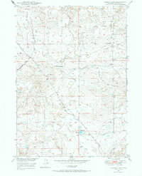
1949 Map of Gilbert Lake
USGS Topo · Published 1985About this map
Sage Creek and its seasonal drainage patterns define this mid-century landscape in Converse County. Mapped as part of the Missouri River Basin development program, the area showcases a rural ranching economy centered around water management and transport. Gilbert Lake sits at the heart of the southern terrain, fed by the Gilbert Ditch, illustrating the critical role of irrigation and water storage in this arid environment. Transportation through the hills is facilitated by the Ross Road and the Glenrock-Ross Road, which connect the remote Smith Ranch to larger regional hubs. The presence of a prominent Pipe Line running through the southern sections points to the early energy infrastructure that would become a staple of the Wyoming landscape. This topographic record preserves the specific layout of fencelines and windmills essential to high-plains operations before the era of modern consolidation.
Find a feature on this map
8 named features on this map. Tap any name to fly to it.
Don’t see what you’re looking for? This feature index may not catch every label — zoom into the map to look around manually.
Map Details
Editions of this 1949 Gilbert Lake Map
2 editions found
Other maps of this area

1949 · Sundquist Ranch
USGS Topo · 1:24,000

1949 · Orpha
USGS Topo · 1:24,000

1949 · Careyhurst
USGS Topo · 1:24,000

1949 · Gilbert Lake
USGS Topo · 1:24,000

1949 · Douglas
USGS Topo · 1:24,000

1949 · Leuenberger Ranch
USGS Topo · 1:24,000

1950 · Careyhurst
USGS Topo · 1:24,000

1950 · Gilbert Lake
USGS Topo · 1:24,000

1950 · Leuenberger Ranch
USGS Topo · 1:24,000

1950 · Douglas
USGS Topo · 1:24,000