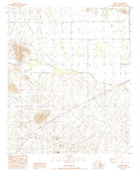
1984 Map of Gillespie
USGS Topo · Published 1984About this map
Gillespie and the Crag (Site) represent the sparse but vital human footprint across this arid Maricopa County corridor in the early 1980s. The landscape is dominated by the prominent peaks of the Yellow Medicine Hills, the Rose Hills, and the Palo Verde Hills, which frame a complex network of seasonal drainages including Centennial Wash and Winters Wash. The infrastructure of the era is clearly visible, with the Southern Pacific railroad line and a large-scale gas pipeline traversing the basin. Water management is a primary theme of the map, evidenced by remote infrastructure like the Petterson Tank and several strategically placed wells, such as the Desert Farms Well No 1 and Galleta Well, which supported local ranching and mining efforts near landmarks like Black Butte and the Butte Mine.
Find a feature on this map
21 named features on this map. Tap any name to fly to it.
Don’t see what you’re looking for? This feature index may not catch every label — zoom into the map to look around manually.
Map Details
Editions of this 1984 Gillespie Map
This is the sole edition of this map. No revisions or reprints were ever made.
Other maps of this area

1942 · Vicksburg
USGS Topo · 1:250,000

1951 · Dendora Valley
USGS Topo · 1:62,500

1951 · Woolsey Peak
USGS Topo · 1:62,500

1954 · Phoenix
USGS Topo · 1:250,000

1957 · Phoenix
USGS Topo · 1:250,000

1958 · Phoenix
USGS Topo · 1:250,000

1960 · Phoenix
USGS Topo · 1:250,000

1962 · Cortez Peak
USGS Topo · 1:62,500

1962 · Arlington
USGS Topo · 1:62,500

1969 · Phoenix
USGS Topo · 1:250,000