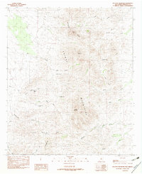
1982 Map of Gillespie Mountain
USGS Topo · Published 1982About this map
The Continental Divide winds through this high-altitude landscape of the Animas Mountains in southwestern New Mexico. This 1982 provisional edition showcases a terrain defined by high peaks and strategic water management, with numerous named catchments like Pigpen Tank, Gillespie Tank, and South Pigpen Tank supporting the region's ranching or wildlife needs. Human impact is most visible in the southern reaches, where Open Pit Mines and various Prospects suggest a history of mineral exploration in the shadow of Gillespie Mountain. Drainage patterns are clearly delineated, with several seasonal waterways such as Millsite Creek, Ash Creek, and Double Adobe Creek flowing from the divide. The map also identifies local landmarks like Maverick Flat and Anderson Mountain, providing a detailed look at the physical geography of Hidalgo County before more modern developments.
Find a feature on this map
25 named features on this map. Tap any name to fly to it.
Don’t see what you’re looking for? This feature index may not catch every label — zoom into the map to look around manually.
Map Details
Editions of this 1982 Gillespie Mountain Map
This is the sole edition of this map. No revisions or reprints were ever made.
Other maps of this area

1918 · Walnut Wells
USGS Topo · 1:62,500

1918 · Playas
USGS Topo · 1:62,500

1918 · Animas Peak
USGS Topo · 1:62,500

1918 · Pratt
USGS Topo · 1:62,500

1919 · Pratt
USGS Topo · 1:62,500

1919 · Playas
USGS Topo · 1:62,500

1920 · Animas Peak
USGS Topo · 1:62,500

1923 · Walnut Wells
USGS Topo · 1:62,500

1955 · Douglas
USGS Topo · 1:250,000

1959 · Douglas
USGS Topo · 1:250,000