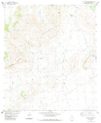
1983 Map of Gilliland Peak
USGS Topo · Published 1984About this map
Gilliland Peak and Chichi Peak dominate the high ridges of the eastern Glass Mountains in Brewster County. This 1980s landscape reveals the infrastructure of Trans-Pecos ranching, where survival depends on a network of isolated water sources like West Pasture Well, Canyon Windmill, and Double Windmills. A single ranching complex, Iron Mountain Ranch, sits near the base of Iron Mountain in the eastern portion of the quadrangle. For those researching local history or genealogy, the map identifies specific small landmarks such as a lone Grave south of the peaks and a small Cem near the northern boundary. The terrain transitions from the heights of Cathedral Mountain into the drainage of Moose Draw, providing a detailed look at the land use and topography of West Texas during this era.
Find a feature on this map
16 named features on this map. Tap any name to fly to it.
Don’t see what you’re looking for? This feature index may not catch every label — zoom into the map to look around manually.
Map Details
Editions of this 1983 Gilliland Peak Map
This is the sole edition of this map. No revisions or reprints were ever made.
Other maps of this area

1920 · Monument Spring
USGS Topo · 1:62,500

1920 · Marathon
USGS Topo · 1:62,500

1921 · Monument Spring
USGS Topo · 1:62,500

1921 · Marathon
USGS Topo · 1:62,500

1923 · Hess Canyon
USGS Topo · 1:62,500

1923 · Altuda
USGS Topo · 1:62,500

1954 · Fort Stockton
USGS Topo · 1:250,000

1958 · Fort Stockton
USGS Topo · 1:250,000

1973 · Fort Stockton
USGS Topo · 1:250,000
1983 · Dugout Mountain
USGS Topo · 1:24,000