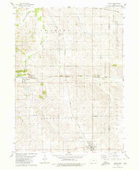
1980 Map of Gilman
USGS Topo · Published 1980About this map
The agrarian landscape of Marshall and Tama counties is defined by its mid-century rail corridors and small rural service centers. Gilman stands as the primary hub in the south, supported by the Gilman Waterworks and served by the Chicago and North Western rail line. To the north, the small settlements of Ferguson, Pickering, and Dillon mark the path of the Chicago Milwaukee St Paul and Pacific railroad, illustrating the importance of these transport veins to the local grain-and-livestock economy. Religious and community life is anchored by landmarks like Stavanger Ch and Trinity Ch, while the Prairie View Cemetery provides a genealogical touchstone for the Greencastle and Highland townships. The map also reveals the drainage patterns of North Timber Creek and Brush Creek, showing how the rolling Iowa topography shaped the placement of farms and railroads.
Find a feature on this map
25 named features on this map. Tap any name to fly to it.
Don’t see what you’re looking for? This feature index may not catch every label — zoom into the map to look around manually.
Map Details
Editions of this 1980 Gilman Map
This is the sole edition of this map. No revisions or reprints were ever made.
Other maps of this area

1954 · Waterloo
USGS Topo · 1:250,000

1954 · Des Moines
USGS Topo · 1:250,000

1955 · Waterloo
USGS Topo · 1:250,000

1956 · Des Moines
USGS Topo · 1:250,000

1957 · Des Moines
USGS Topo · 1:250,000

1960 · Marshalltown
USGS Topo · 1:24,000

1960 · Marshalltown
USGS Topo · 1:62,500

1960 · Le Grand
USGS Topo · 1:24,000

1969 · Des Moines
USGS Topo · 1:250,000

1971 · Garwin
USGS Topo · 1:24,000