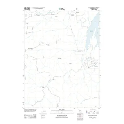
2012 Map of Gilmore Peak
USGS Topo · Published 2012About this map
Stonyford serves as a primary hub in this corner of Colusa County, home to the Stonyford District Ranger Office and the Stonyford Rodeo Grounds. The settlement pattern transitions from the organized town grid at the north to the residential clusters of Century Ranch further south. The landscape is defined by the drainage of Stony Cr and its many tributaries, including Salt Cr and Hyphus Cr, which carve through prominent ridgelines like Crackerbox Ridge and Gilmore Ridge. To the east, the waters of East Park Reservoir provide a major geographic anchor for the region. Historical sites and local landmarks are scattered throughout the valleys, from the Stonyford Cem to the thermal waters of Cooks Springs near Indian Cr. The map also documents a network of forest routes, such as Forest Rte 17N15, providing access to isolated landmarks like Wolf Glade and the summit of Gilmore Peak.
Find a feature on this map
46 named features on this map. Tap any name to fly to it.
Don’t see what you’re looking for? This feature index may not catch every label — zoom into the map to look around manually.
Map Details
Editions of this 2012 Gilmore Peak Map
This is the sole edition of this map. No revisions or reprints were ever made.
Other maps of this area

1920 · Venado
USGS Topo · 1:62,500

1924 · Bartlett Springs
USGS Topo · 1:62,500

1942 · Bartlett Springs
USGS Topo · 1:62,500

1943 · Lodoga
USGS Topo · 1:62,500

1944 · Bartlett Springs
USGS Topo · 1:62,500

1944 · Wilbur Springs
USGS Topo · 1:62,500

1951 · Stonyford
USGS Topo · 1:62,500

1957 · Ukiah
USGS Topo · 1:250,000

1960 · Ukiah
USGS Topo · 1:250,000
1960 · Clearlake Oaks
USGS Topo · 1:62,500