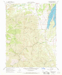
1968 Map of Gilmore Peak
USGS Topo · Published 1969About this map
Mendocino National Forest dominates this Colusa County landscape, where the steep terrain of Gilmore Ridge and Sullivan Ridge gives way to the open waters of the East Park Reservoir. The map illustrates a transitional zone between the high ridges of Gilmore Peak and the agricultural lands of Indian Valley. In the lower elevations, the human presence is marked by infrastructure like the Diversion Dam and Gaging Station on Stony Creek.
Find a feature on this map
33 named features on this map. Tap any name to fly to it.
Don’t see what you’re looking for? This feature index may not catch every label — zoom into the map to look around manually.
Map Details
Editions of this 1968 Gilmore Peak Map
This is the sole edition of this map. No revisions or reprints were ever made.
Other maps of this area

1920 · Venado
USGS Topo · 1:62,500

1924 · Bartlett Springs
USGS Topo · 1:62,500

1942 · Bartlett Springs
USGS Topo · 1:62,500

1943 · Lodoga
USGS Topo · 1:62,500

1944 · Bartlett Springs
USGS Topo · 1:62,500

1944 · Wilbur Springs
USGS Topo · 1:62,500

1951 · Stonyford
USGS Topo · 1:62,500

1957 · Ukiah
USGS Topo · 1:250,000

1960 · Ukiah
USGS Topo · 1:250,000
1960 · Clearlake Oaks
USGS Topo · 1:62,500