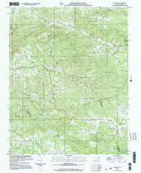
2000 Map of Gilreath
USGS Topo · Published 2003About this map
Brushy Mountains define the central topography of this Piedmont region, where the convergence of Wilkes, Alexander, and Iredell counties creates a complex landscape of ridges and creek valleys. The map documents the distinct transition between Old Gilreath and the more contemporary settlement of Gilreath, providing a spatial record of local community movement. A network of rural congregations and burial grounds, such as Hunting Creek Ch and Bakers Grove Cem, are scattered along historic routes like Salisbury Road and Vannoy Ridge Road. In the southern reaches, the South Yadkin River flows near Bethel Ch, while the north is drained by Hunting Creek and Little Hunting Creek. This survey captures the rural character of the area at the turn of the millennium, anchored by family-named landmarks and the presence of a Quarry near Liberty Ch.
Find a feature on this map
36 named features on this map. Tap any name to fly to it.
Don’t see what you’re looking for? This feature index may not catch every label — zoom into the map to look around manually.
Map Details
Editions of this 2000 Gilreath Map
This is the sole edition of this map. No revisions or reprints were ever made.
Other maps of this area

1889 · Wilkesboro
USGS Topo · 1:125,000

1891 · Wilkesboro
USGS Topo · 1:125,000

1891 · Yadkinville
USGS Topo · 1:125,000

1893 · Statesville
USGS Topo · 1:125,000

1893 · Yadkinville
USGS Topo · 1:125,000

1895 · Hickory
USGS Topo · 1:125,000

1953 · Charlotte
USGS Topo · 1:250,000

1953 · Winston-Salem
USGS Topo · 1:250,000

1954 · Charlotte
USGS Topo · 1:250,000

1955 · Winston-Salem
USGS Topo · 1:250,000