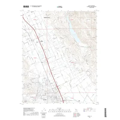
2018 Map of Gilroy
USGS Topo · Published 2018About this map
The Santa Clara Valley serves as a corridor for settlement and agriculture, framed by the heights of the Diablo Range and the Santa Cruz Mountains. This 2018 survey detail shows the urban growth of Gilroy and Morgan Hill along the valley floor, connected by the smaller communities of San Martin, Rucker, and Lonoke. The landscape is a mix of dense residential networks and open drainage systems, where Miller Slough and the Uvas Creek intersect the outskirts of the primary settlements. Genealogists and local historians can find significant landmarks such as the Independent Order of Oddfellows Cemetery and Saint Marys Cemetery, while the presence of the San Martin Airport highlights the region's infrastructure. To the east, the terrain rises sharply toward Larios Peak and Coyote Lake, illustrating the topographical boundary between the developed valley and the steep ridges of the Palassou Ridge.
Find a feature on this map
206 named features on this map. Tap any name to fly to it.
Don’t see what you’re looking for? This feature index may not catch every label — zoom into the map to look around manually.
Map Details
Editions of this 2018 Gilroy Map
This is the sole edition of this map. No revisions or reprints were ever made.
Other maps of this area

1915 · San Juan Bautista
USGS Topo · 1:48,000

1917 · Morgan Hill
USGS Topo · 1:62,500

1917 · San Juan Bautista
USGS Topo · 1:62,500

1919 · Hollister
USGS Topo · 1:48,000

1921 · Gilroy Hot Springs
USGS Topo · 1:62,500

1921 · Hollister
USGS Topo · 1:62,500

1923 · Hollister
USGS Topo · 1:62,500

1939 · Morgan Hill
USGS Topo · 1:62,500

1939 · Gilroy Hot Springs
USGS Topo · 1:62,500

1939 · San Juan Bautista
USGS Topo · 1:62,500